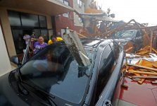
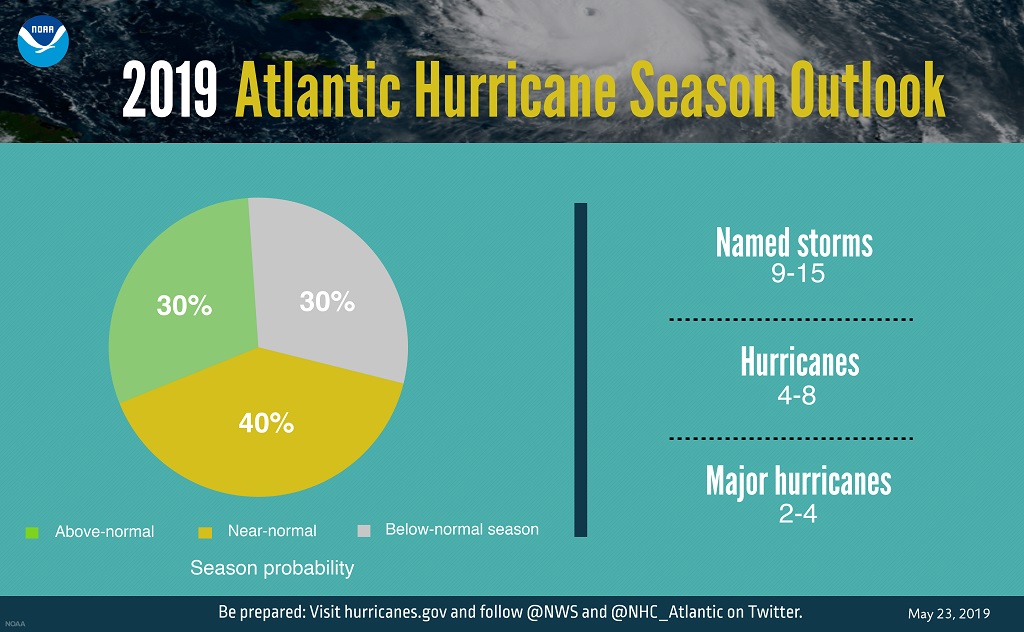
The US National Oceanic and Atmospheric Administration is forecasting 'near-normal' conditions for the 2019 Atlantic hurricane season with approximately nine to 15 named storms, of which four to eight could become hurricanes.
The NOAA issued a statement on May 23 saying its
Climate Prediction Center is predicting that a near-normal Atlantic hurricane season is most likely this year.
This outlook forecasts a 40% chance of a near-normal season, a 30% chance of an above-normal season and a 30% chance of a below-normal season. The hurricane season officially extends from June 1 to November 30.
For 2019, NOAA predicts a likely range of nine to 15 named storms (winds of 39 mph or higher), of which four to eight could become hurricanes (winds of 74 mph or higher), including 2 to 4 major hurricanes (category 3, 4 or 5; with winds of 111 mph or higher).
NOAA said it provides these ranges with a 70% confidence. An average hurricane season produces 12 named storms, of which 6 become hurricanes, including 3 major hurricanes.
“With the 2019 hurricane season upon us, NOAA is leveraging cutting-edge tools to help secure Americans against the threat posed by hurricanes and tropical cyclones across both the Atlantic and Pacific,” said Secretary of Commerce Wilbur Ross. “Throughout hurricane season, dedicated NOAA staff will remain on alert for any danger to American lives and communities.”
The NOAA said this outlook reflects competing climate factors.
The ongoing El Nino is expected to persist and suppress the intensity of the hurricane season. Countering El Nino is the expected combination of warmer-than-average sea-surface temperatures in the tropical Atlantic Ocean and Caribbean Sea, and an enhanced west African monsoon, both of which favor increased hurricane activity.
“New satellite data and other upgrades to products and services from NOAA enable a more Weather-Ready Nation by providing the public and decision makers with the information needed to take action before, during, and after a hurricane,” said Neil Jacobs, Ph.D., acting NOAA administrator.
'Above-average' storm conditions in Central Pacific
However the NOAA said there's a 70 percent chance of above-average conditions are for the central Pacific, with a 70 percent probability of 15-22 names storms, eight to 13 of which are expected to become hurricanes, including four to eight major hurricanes.
The central Pacific outlook calls for a 70% probability of 5 to 8 tropical cyclones, which includes tropical depressions, tropical storms, and hurricanes.
“Preparing ahead of a disaster is the responsibility of all levels of government, the private sector, and the public," said Daniel Kaniewski, Ph.D., FEMA deputy administrator for resilience.
“It only takes one event to devastate a community so now is the time to prepare. Do you have cash on hand? Do you have adequate insurance, including flood insurance? Does your family have communication and evacuation plans? Stay tuned to your local news and download the FEMA app to get alerts, and make sure you heed any warnings issued by local officials.”
NOAA’s Climate Prediction Center will update the 2019 Atlantic seasonal outlook in August just prior to the historical peak of the season.
NOAA’s outlook is for overall seasonal activity and is not a landfall forecast. Hurricane preparedness is critically important for the 2019 hurricane season, just as it is every year.
NOAA to upgrade Global Forecast System (GFS) weather model
The NOAA said the 2019 hurricane season marks the first time NOAA’s fleet of Earth-observing satellites includes three operational next-generation satellites. Unique and valuable data from these satellites feed the hurricane forecast models used by forecasters to help users make critical decisions days in advance
NOAA’s
National Weather Service is making a planned upgrade to its Global Forecast System (GFS) flagship weather model – often called the American model – early in the 2019 hurricane season. This marks the first major upgrade to the dynamical core of the model in almost 40 years and will improve tropical cyclone track and intensity forecasts. “NOAA is driving towards a community-based development program for future weather and climate modeling to deliver the very best forecasts, by leveraging new investments in research and working with the weather enterprise,” added Jacobs.
NOAA’s
National Hurricane Center and NWS office in San Juan will expand the coastal
storm surge watches and warnings in 2019 to include Puerto Rico and the U.S. Virgin Islands. In addition, NHC will display excessive rainfall outlooks on its website, providing greater visibility of one of the most dangerous inland threats from hurricanes.
Also, this season, NOAA’s
Hurricane Hunter aircraft will collect higher-resolution data from upgraded onboard radar systems. These enhanced observations will be transmitted in near-real time to hurricane specialists at the National Hurricane Center, the Central Pacific Hurricane Center and forecasters at NWS Weather Forecast Offices.
Visit the National Hurricane Center’s website at hurricanes.gov throughout the season to stay current on any watches and warnings.